Geolocate

Pavaratty topographic map

Click on the map to display elevation.

About this map

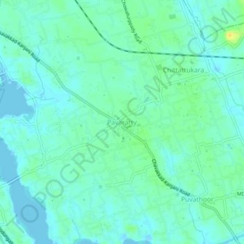
Name: Pavaratty topographic map, elevation, terrain.

Location: Pavaratty, Chavakkad, Thrissur District, Kerala, 680507, India (10.54582 76.04214 10.58582 76.08214)

Average elevation: 7 m

Minimum elevation: -4 m

Maximum elevation: 24 m

Other topographic maps

Click on a map to view its topography, its elevation and its terrain.

Chettuva

India > Kerala > Chavakkad

Average elevation: 3 m

Guruvayoor

India > Kerala > Chavakkad > Guruvayur

Average elevation: 5 m

Perakam

India > Kerala > Chavakkad > Chavakkad

Average elevation: 6 m

Orumanayoor

India > Kerala > Chavakkad > Orumanayur

Average elevation: 4 m

Guruvayoor

India > Kerala > Chavakkad > Chavakkad

Average elevation: 5 m

Gear up for your next adventure:

🥾Waterproof Hiking Boots - Essential footwear for rugged terrain and wet Canadian trails
🚲Handlebar Phone Mount - View topographic-map.com live while cycling
🧥Thermal Layer - Insulating layer for cold outdoor conditions
💡Solar Camping Lamp - Eco-friendly lighting for campsites
🥾Trail Hiking Boots - Supportive boots for rough trails

As an Amazon Associate, this site earns from qualifying purchases at no extra cost to you.