
Make a donation
Gear up for your next adventure:
As an Amazon Associate, this site earns from qualifying purchases at no extra cost to you.
Les Vignes topographic map
Click on the map to display elevation.
Make a donation
Gear up for your next adventure:
As an Amazon Associate, this site earns from qualifying purchases at no extra cost to you.
Les Vignes
Le village est construit au bord du Tarn, sur les flancs du plateau calcaire du causse de Sauveterre, face au causse Méjean, à environ 400 m d'altitude.
Make a donation
Gear up for your next adventure:
As an Amazon Associate, this site earns from qualifying purchases at no extra cost to you.
About this map
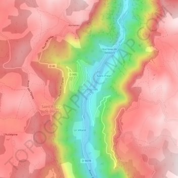
Name: Les Vignes topographic map, elevation, terrain.
Average elevation: 778 m
Minimum elevation: 405 m
Maximum elevation: 996 m
Make a donation
Gear up for your next adventure:
As an Amazon Associate, this site earns from qualifying purchases at no extra cost to you.
Other topographic maps
Click on a map to view its topography, its elevation and its terrain.
Les Vignes
France > Occitanie > Lozère > Massegros Causses Gorges
Le village est construit au bord du Tarn, sur les flancs du plateau calcaire du causse de Sauveterre, face au causse Méjean, à environ 400 m d'altitude.
Average elevation: 850 m
Saint-Georges-de-Lévéjac
France > Occitanie > Lozère > Massegros Causses Gorges
Average elevation: 864 m
Make a donation
Gear up for your next adventure:
As an Amazon Associate, this site earns from qualifying purchases at no extra cost to you.