Geolocate

Montan topographic map

Click on the map to display elevation.

About this map

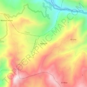
Name: Montan topographic map, elevation, terrain.

Location: Montan, Lajas, Province of Chota, Cajamarca, Peru (-6.58651 -78.79495 -6.54651 -78.75495)

Average elevation: 2,483 m

Minimum elevation: 2,037 m

Maximum elevation: 2,878 m

Gear up for your next adventure:

🚑Survival Whistle - Signal for help across long distances in mountains
🧢Hiking Hat - Sun-protective and breathable hats for long treks
🧳Compression Sacks - Maximize space in your backpack by shrinking gear
🥽Outdoor Goggles - Protective eyewear for outdoor activities
🥾Mountain Trail Shoes - High-traction shoes for mountain trails

As an Amazon Associate, this site earns from qualifying purchases at no extra cost to you.