
Make a donation
Gear up for your next adventure:
As an Amazon Associate, this site earns from qualifying purchases at no extra cost to you.
Cabot topographic map
Click on the map to display elevation.
Make a donation
Gear up for your next adventure:
As an Amazon Associate, this site earns from qualifying purchases at no extra cost to you.
About this map
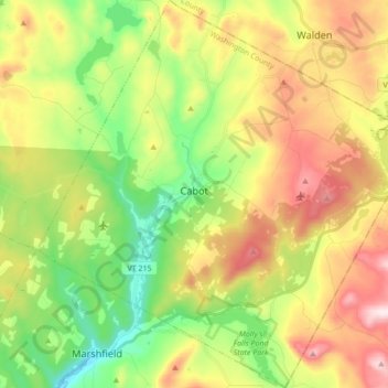
Name: Cabot topographic map, elevation, terrain.
Location: Cabot, Washington County, Vermont, 05647, United States (44.34037 -72.37990 44.46317 -72.21718)
Average elevation: 458 m
Minimum elevation: 235 m
Maximum elevation: 758 m
Make a donation
Gear up for your next adventure:
As an Amazon Associate, this site earns from qualifying purchases at no extra cost to you.
Other topographic maps
Click on a map to view its topography, its elevation and its terrain.
Make a donation
Gear up for your next adventure:
As an Amazon Associate, this site earns from qualifying purchases at no extra cost to you.
North Montpelier
United States > Vermont > Washington County > East Montpelier
Average elevation: 278 m