
Mietków topographic map
Interactive map
Click on the map to display elevation.
About this map
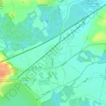
Name: Mietków topographic map, elevation, terrain.
Average elevation: 160 m
Minimum elevation: 150 m
Maximum elevation: 186 m
Other topographic maps
Click on a map to view its topography, its elevation and its terrain.
Iwiny
Poland > Lower Silesian Voivodeship > Wrocław County
Iwiny, gmina Siechnice, Wrocław County, Lower Silesian Voivodeship, Poland
Average elevation: 125 m
Sobótka
Poland > Lower Silesian Voivodeship > Wrocław County
Sobótka, gmina Sobótka, Wrocław County, Lower Silesian Voivodeship, Poland
Average elevation: 260 m