
Make a donation
Gear up for your next adventure:
As an Amazon Associate, this site earns from qualifying purchases at no extra cost to you.
Meuselbach topographic map
Click on the map to display elevation.
Make a donation
Gear up for your next adventure:
As an Amazon Associate, this site earns from qualifying purchases at no extra cost to you.
About this map
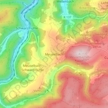
Name: Meuselbach topographic map, elevation, terrain.
Average elevation: 580 m
Minimum elevation: 383 m
Maximum elevation: 778 m
Make a donation
Gear up for your next adventure:
As an Amazon Associate, this site earns from qualifying purchases at no extra cost to you.
Other topographic maps
Click on a map to view its topography, its elevation and its terrain.
Mellenbach-Glasbach
Deutschland > Thüringen > Landkreis Saalfeld-Rudolstadt > Schwarzatal
Mellenbach-Glasbach ist ein Straßendorf, das sich mehr als fünf Kilometer im Schwarzatal erstreckt. Die Höhenlage des Ortes beträgt im unteren Schwarzatal etwa 380 Meter, Berge rechts und links des Tales steigen bis auf 600 Meter Höhe an. Insgesamt ist das Tal nur sehr schmal, sodass es von der Straße,…
Average elevation: 512 m
Oberweißbach/Thüringer Wald
Deutschland > Thüringen > Landkreis Saalfeld-Rudolstadt > Schwarzatal
Average elevation: 590 m