Geolocate

Zutphen topographic map

Click on the map to display elevation.

About this map

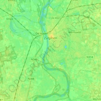
Name: Zutphen topographic map, elevation, terrain.

Location: Zutphen, Gelderland, Netherlands (52.08873 6.14039 52.16980 6.27499)

Average elevation: 9 m

Minimum elevation: -1 m

Maximum elevation: 17 m

Other topographic maps

Click on a map to view its topography, its elevation and its terrain.

Waterberg

Netherlands > Gelderland > Arnhem

Average elevation: 57 m

Gear up for your next adventure:

🧦Outdoor Socks - Durable socks designed for hiking and outdoor sports
🌬️Windproof Camp Stove - Efficient cooking even on exposed mountain peaks
🔋Lithium AA Batteries - Long-lasting power that performs in extreme cold
👟Sport Hiking Sandals - Breathable footwear for water crossings and camp rest
🛏️Camping Sleeping Mat - Comfortable mats for sleeping outdoors

As an Amazon Associate, this site earns from qualifying purchases at no extra cost to you.