Geolocate

Singopuran topographic map

Click on the map to display elevation.

About this map

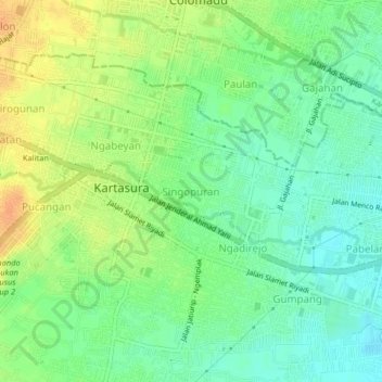
Name: Singopuran topographic map, elevation, terrain.

Location: Singopuran, Sukoharjo, Central Java, Java, 57169, Indonesia (-7.57250 110.72788 -7.53250 110.76788)

Average elevation: 121 m

Minimum elevation: 105 m

Maximum elevation: 140 m

Other topographic maps

Click on a map to view its topography, its elevation and its terrain.

Puron

Indonesia > Central Java > Sukoharjo

Average elevation: 128 m

Bulu

Indonesia > Central Java > Sukoharjo

Average elevation: 126 m

Lapangan Makamhaji

Indonesia > Central Java > Sukoharjo > Gentan > Kuyudan

Average elevation: 104 m

Waduk Mulur

Indonesia > Central Java > Sukoharjo > Bendosari

Average elevation: 114 m

Karangasem

Indonesia > Central Java > Sukoharjo > Karangasem

Average elevation: 115 m

Gear up for your next adventure:

🥾Hiking Boots - Sturdy boots providing ankle support and traction on rugged trails
🥘Camping Cookware Set - Compact nesting pots and pans for trail cooking
🧭GPS Tracker - Track your location in remote areas safely
🦌Outdoor Trail Camera - Monitor wildlife activity near your favorite spots
🛰️Satellite Messenger - Emergency communication for areas with no cell service

As an Amazon Associate, this site earns from qualifying purchases at no extra cost to you.