
Thank you for supporting this site ❤️
Make a donation
Make a donation
Gear up for your next adventure:
As an Amazon Associate, this site earns from qualifying purchases at no extra cost to you.
Brucei/Burcei topographic map
Click on the map to display elevation.
Thank you for supporting this site ❤️
Make a donation
Make a donation
Gear up for your next adventure:
As an Amazon Associate, this site earns from qualifying purchases at no extra cost to you.
About this map
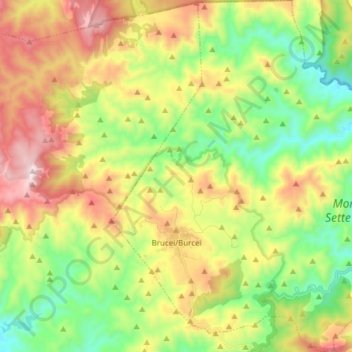
Name: Brucei/Burcei topographic map, elevation, terrain.
Location: Brucei/Burcei, Sud Sardegna, Sardinië, 09040, Italië (39.30596 9.33131 39.42419 9.47031)
Average elevation: 507 m
Minimum elevation: 125 m
Maximum elevation: 1,063 m
Thank you for supporting this site ❤️
Make a donation
Make a donation
Gear up for your next adventure:
As an Amazon Associate, this site earns from qualifying purchases at no extra cost to you.
Other topographic maps
Click on a map to view its topography, its elevation and its terrain.