Geolocate

Case Benti topographic map

Click on the map to display elevation.

About this map

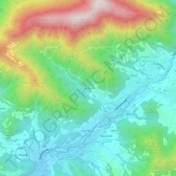
Name: Case Benti topographic map, elevation, terrain.

Location: Case Benti, Luzzana, Bergamo, Lombardia, 24069, Italia (45.69991 9.85416 45.73991 9.89416)

Average elevation: 514 m

Minimum elevation: 258 m

Maximum elevation: 1,063 m

Other topographic maps

Click on a map to view its topography, its elevation and its terrain.

Case Benti

Italia > Lombardia > Bergamo > Luzzana

Average elevation: 399 m

Gear up for your next adventure:

🧶550 Survival Paracord - Versatile utility cord for emergency repairs and rigging
🧼Travel Hand Sanitizer - Keep hands clean when water is scarce
🧥Softshell Hiking Jacket - The perfect balance of wind protection and breathability
🥾Durable Hiking Shoes - Long-lasting shoes for frequent hiking
🍽️Titanium Camping Spork - Ultralight and indestructible eating utensil

As an Amazon Associate, this site earns from qualifying purchases at no extra cost to you.