
Make a donation
Gear up for your next adventure:
As an Amazon Associate, this site earns from qualifying purchases at no extra cost to you.
Pfalzel topographic map
Click on the map to display elevation.
Make a donation
Gear up for your next adventure:
As an Amazon Associate, this site earns from qualifying purchases at no extra cost to you.
Pfalzel
Pfalzel bezeichnet das Messtischblatt Nr. 6206 (früher Nr. 3477) der topografischen Karte im Maßstab 1:25.000.
Make a donation
Gear up for your next adventure:
As an Amazon Associate, this site earns from qualifying purchases at no extra cost to you.
About this map
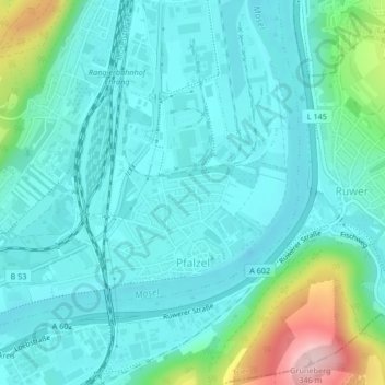
Name: Pfalzel topographic map, elevation, terrain.
Location: Pfalzel, Trier, Rheinland-Pfalz, Deutschland (49.77708 6.67647 49.79320 6.70447)
Average elevation: 159 m
Minimum elevation: 114 m
Maximum elevation: 345 m
Make a donation
Gear up for your next adventure:
As an Amazon Associate, this site earns from qualifying purchases at no extra cost to you.
Other topographic maps
Click on a map to view its topography, its elevation and its terrain.
Make a donation
Gear up for your next adventure:
As an Amazon Associate, this site earns from qualifying purchases at no extra cost to you.
Make a donation
Gear up for your next adventure:
As an Amazon Associate, this site earns from qualifying purchases at no extra cost to you.