
Thank you for supporting this site ❤️
Make a donation
Make a donation
Gear up for your next adventure:
As an Amazon Associate, this site earns from qualifying purchases at no extra cost to you.
Campanil topographic map
Click on the map to display elevation.
Thank you for supporting this site ❤️
Make a donation
Make a donation
Gear up for your next adventure:
As an Amazon Associate, this site earns from qualifying purchases at no extra cost to you.
About this map
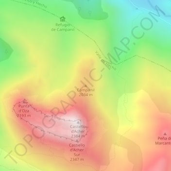
Name: Campanil topographic map, elevation, terrain.
Location: Campanil, Valle de Hecho, Jacétanie, Huesca, Aragon, Espagne (42.82856 -0.66644 42.82866 -0.66634)
Average elevation: 1,859 m
Minimum elevation: 1,322 m
Maximum elevation: 2,365 m
Thank you for supporting this site ❤️
Make a donation
Make a donation
Gear up for your next adventure:
As an Amazon Associate, this site earns from qualifying purchases at no extra cost to you.