Geolocate

Coldwater topographic map

Click on the map to display elevation.

About this map

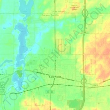
Name: Coldwater topographic map, elevation, terrain.

Location: Coldwater, Branch County, Michigan, United States (41.91658 -85.04757 41.99473 -84.95543)

Average elevation: 295 m

Minimum elevation: 279 m

Maximum elevation: 317 m

Gear up for your next adventure:

🦟Insect Repellent - Keep mosquitoes and black flies away in wooded areas
🥾Approach Boots - Comfortable boots for hiking and climbing approaches
🥾Durable Hiking Shoes - Long-lasting shoes for frequent hiking
🧤Thermal Hiking Gloves - Grip-enhanced gloves for cold-weather altitude trekking
🧥Packable Rain Jacket - Breathable waterproof layer for unpredictable weather

As an Amazon Associate, this site earns from qualifying purchases at no extra cost to you.