Geolocate

Mozzio topographic map

Click on the map to display elevation.

About this map

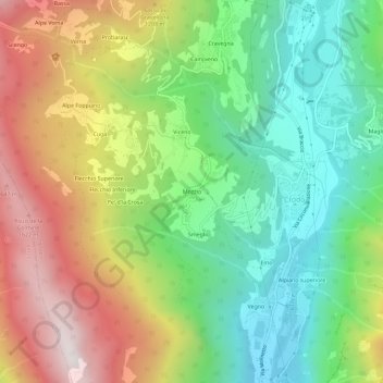
Name: Mozzio topographic map, elevation, terrain.

Location: Mozzio, Crodo, Verbano-Cusio-Ossola, Piemonte, 28862, Italia (46.20408 8.28846 46.24408 8.32846)

Average elevation: 957 m

Minimum elevation: 408 m

Maximum elevation: 1,752 m

Other topographic maps

Click on a map to view its topography, its elevation and its terrain.

Valle Antigorio

Italia > Piemonte > Verbano-Cusio-Ossola > Crodo

Average elevation: 1,602 m

Gear up for your next adventure:

🥾All-Terrain Hiking Boots - Versatile boots for varied hiking conditions
🔭Compact Binoculars - Lightweight optics for scouting trails and wildlife
🥾Waterproof Hiking Boots - Boots keeping your feet dry in wet conditions
🔥Emergency Fire Starter - Reliable ignition source for all weather conditions
🧼Travel Hand Sanitizer - Keep hands clean when water is scarce

As an Amazon Associate, this site earns from qualifying purchases at no extra cost to you.