Geolocate

Aven topographic map

Click on the map to display elevation.

About this map

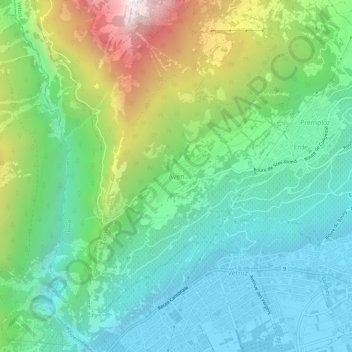
Name: Aven topographic map, elevation, terrain.

Location: Aven, Conthey, Wallis, 1964, Switzerland (46.21629 7.25120 46.25629 7.29120)

Average elevation: 940 m

Minimum elevation: 476 m

Maximum elevation: 2,061 m

Other topographic maps

Click on a map to view its topography, its elevation and its terrain.

Mordor

Switzerland > Wallis > Conthey > Conthey

Average elevation: 1,702 m

Gear up for your next adventure:

Backpacking Tent - Lightweight tent for long-distance hiking trips
🛶Canoe Life Vest - Safety vest for water sports
🧣Merino Neck Gaiter - Protects against wind, sun, and cold at high altitudes
🥾All-Terrain Hiking Boots - Versatile boots for varied hiking conditions
Lightweight Backpacking Tent - Compact tent for efficient hiking trips

As an Amazon Associate, this site earns from qualifying purchases at no extra cost to you.