Geolocate

Dhangadhi topographic map

Click on the map to display elevation.

About this map

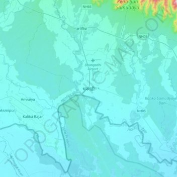
Name: Dhangadhi topographic map, elevation, terrain.

Location: Dhangadhi, Kailali, Sudurpashchim Province, Nepal (28.54330 80.40702 28.86330 80.72702)

Average elevation: 193 m

Minimum elevation: 156 m

Maximum elevation: 951 m

Other topographic maps

Click on a map to view its topography, its elevation and its terrain.

Bhajani

Nepal > Sudurpashchim Province > Kailali

Average elevation: 152 m

Bhajani

Nepal > Sudurpashchim Province > Kailali

Average elevation: 152 m

Chure

Nepal > Sudurpashchim Province > Kailali

Average elevation: 939 m

Gear up for your next adventure:

🏕️Camping Hammock - Integrated protection for sleeping between trees
🥾Mountain Trail Shoes - High-traction shoes for mountain trails
🧊Portable Cooler - Keep food and drinks cold during outdoor adventures
👟Sport Hiking Sandals - Breathable footwear for water crossings and camp rest
🩹Compact First Aid Kit - Pre-packed essentials for common trail injuries

As an Amazon Associate, this site earns from qualifying purchases at no extra cost to you.