
Bens topographic map
Click on the map to display elevation.
About this map
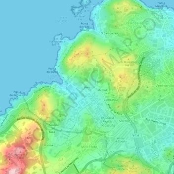
Name: Bens topographic map, elevation, terrain.
Location: Bens, Visma, La Coruña, Galicia, 15191, España (43.33924 -8.46892 43.37924 -8.42892)
Average elevation: 62 m
Minimum elevation: 0 m
Maximum elevation: 244 m
Other topographic maps
Click on a map to view its topography, its elevation and its terrain.
Parque del Monte de San Pedro
España > Galicia > La Coruña > La Coruña > O Campanario
El parque municipal del Monte de San Pedro comprende una amplia extensión de territorio, 78 339 m², de accidentada topografía y vistas sobre la ciudad de La Coruña (España) y una amplia franja de costa, que abarca desde el cabo San Adrián y las Islas Sisargas al oeste, hasta los cabos Prior y Prioriño…
Average elevation: 33 m