Geolocate

Marfil topographic map

Click on the map to display elevation.

About this map

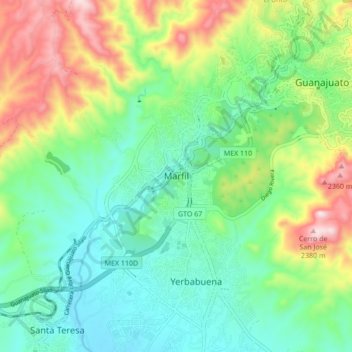
Name: Marfil topographic map, elevation, terrain.

Location: Marfil, Municipio de Guanajuato, Guanajuato, 36250, Mexico (20.95429 -101.32837 21.03429 -101.24837)

Average elevation: 2,045 m

Minimum elevation: 1,875 m

Maximum elevation: 2,403 m

Gear up for your next adventure:

📷Outdoor Action Camera - Capture high-elevation views and rugged adventures
🥾Hiking Shoes - Durable and comfortable shoes for trail hiking
🥾Light Trekking Boots - Supportive boots for multi-day treks
🔭Compact Monocular - One-handed bird watching and trail spotting
💧Hydration Pack - Hands-free hydration system for long hikes

As an Amazon Associate, this site earns from qualifying purchases at no extra cost to you.