Geolocate

Ciguha topographic map

Click on the map to display elevation.

About this map

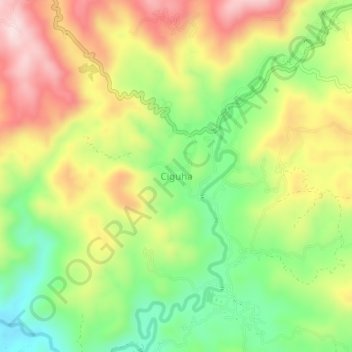
Name: Ciguha topographic map, elevation, terrain.

Location: Ciguha, Cianjur, West Java, Java, Indonesia (-7.15010 107.05796 -7.11010 107.09796)

Average elevation: 842 m

Minimum elevation: 678 m

Maximum elevation: 1,027 m

Other topographic maps

Click on a map to view its topography, its elevation and its terrain.

Sindangbarang

Indonesia > West Java > Cianjur

Average elevation: 148 m

Kertamukti

Indonesia > West Java > Cianjur

Average elevation: 25 m

Wangunjaya

Indonesia > West Java > Cianjur

Average elevation: 17 m

Alun Alun Suryakancana

Indonesia > West Java > Cianjur

Average elevation: 2,568 m

Gear up for your next adventure:

🧊Insulated Water Bottle - Keeps drinks cold in summer and prevents freezing in winter
🚲Bike Repair Kit - Essential tools for on-trail mechanical issues
🛏️Sleeping Bag - Warm and compact sleeping bags for outdoor camping
🥾Lightweight Hiking Shoes - Comfortable shoes for day hikes
🧦Hiking Socks - Moisture-wicking and comfortable socks for long hikes

As an Amazon Associate, this site earns from qualifying purchases at no extra cost to you.