Geolocate

Salagedang topographic map

Click on the map to display elevation.

About this map

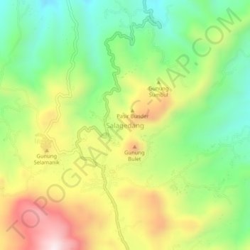
Name: Salagedang topographic map, elevation, terrain.

Location: Salagedang, Cianjur, West Java, Java, Indonesia (-7.01020 107.12460 -6.97020 107.16460)

Average elevation: 913 m

Minimum elevation: 632 m

Maximum elevation: 1,296 m

Other topographic maps

Click on a map to view its topography, its elevation and its terrain.

Sindangbarang

Indonesia > West Java > Cianjur

Average elevation: 148 m

Kertamukti

Indonesia > West Java > Cianjur

Average elevation: 25 m

Wangunjaya

Indonesia > West Java > Cianjur

Average elevation: 17 m

Alun Alun Suryakancana

Indonesia > West Java > Cianjur

Average elevation: 2,568 m

Gear up for your next adventure:

🥽Outdoor Goggles - Protective eyewear for outdoor activities
👟Sport Hiking Sandals - Breathable footwear for water crossings and camp rest
💡Compact LED Flashlight - Powerful and portable flashlight for outdoor use
🧼Travel Hand Sanitizer - Keep hands clean when water is scarce
🧊Portable Cooler - Keep food and drinks cold during outdoor adventures

As an Amazon Associate, this site earns from qualifying purchases at no extra cost to you.