
Piétrain topographic map
Interactive map
Click on the map to display elevation.
About this map
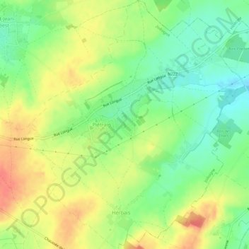
Name: Piétrain topographic map, elevation, terrain.
Location: Piétrain, Jodoigne, Nivelles, Brabant wallon, Wallonie, Belgique (50.70826 4.89996 50.74268 4.94887)
Average elevation: 90 m
Minimum elevation: 64 m
Maximum elevation: 118 m
Other topographic maps
Click on a map to view its topography, its elevation and its terrain.
Arbre de la liberté
Belgique > Brabant wallon > Nivelles > Jodoigne
Arbre de la liberté, Grand'Place, Les Rendanges, Jodoigne, Nivelles, Brabant wallon, Wallonie, 1370, Belgique
Average elevation: 85 m
Gobertange
Belgique > Brabant wallon > Nivelles > Jodoigne
Gobertange, Jodoigne, Nivelles, Brabant wallon, Wallonie, 1370, Belgique
Average elevation: 98 m
Saint-Jean-Geest
Belgique > Brabant wallon > Nivelles > Jodoigne
Saint-Jean-Geest, Jodoigne, Nivelles, Brabant wallon, Wallonie, 1370, Belgique
Average elevation: 82 m
Sainte-Marie-Geest
Belgique > Brabant wallon > Nivelles > Jodoigne > Sainte-Marie-Geest
Sainte-Marie-Geest, Jodoigne, Nivelles, Brabant wallon, Wallonie, 1370, Belgique
Average elevation: 82 m