
勐混镇 topographic map
Interactive map
Click on the map to display elevation.
About this map
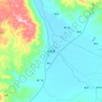
Name: 勐混镇 topographic map, elevation, terrain.
Location: 勐混镇, 勐海县, 西双版纳傣族自治州, 云南省, 666100, 中国 (21.80217 100.34682 21.88217 100.42682)
Average elevation: 1,278 m
Minimum elevation: 1,182 m
Maximum elevation: 1,637 m
Other topographic maps
Click on a map to view its topography, its elevation and its terrain.