
Águas Quentes topographic map
Interactive map
Click on the map to display elevation.
About this map
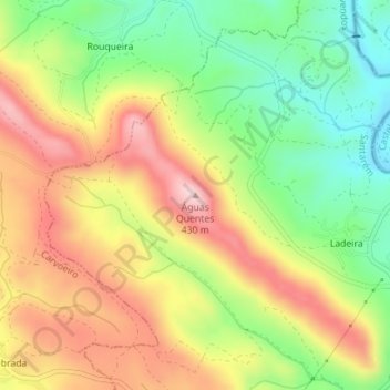
Name: Águas Quentes topographic map, elevation, terrain.
Location: Águas Quentes, Mação, Santarém, Portugal (39.62212 -7.87788 39.62222 -7.87778)
Average elevation: 284 m
Minimum elevation: 148 m
Maximum elevation: 428 m
Other topographic maps
Click on a map to view its topography, its elevation and its terrain.
Casal da Barba Pouca
Portugal > Santarém > Mação > Casal da Barba Pouca
Casal da Barba Pouca, Mação, Penhascoso e Aboboreira, Mação, Santarém, 6120-721, Portugal
Average elevation: 235 m