
Breil topographic map
Click on the map to display elevation.
Breil
L'altitude de la commune varie de 60 à 119 mètres, pour une altitude moyenne de 81 mètres. Le relief du Baugeois est principalement constitué d'un plateau, aux terrains sablonneux, siliceux ou calcaires, caractérisés par de larges affleurements sédimentaires, crétacés, sables et calcaires aux teintes claires.
About this map
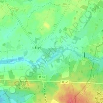
Name: Breil topographic map, elevation, terrain.
Average elevation: 81 m
Minimum elevation: 59 m
Maximum elevation: 124 m
Other topographic maps
Click on a map to view its topography, its elevation and its terrain.
Barrage des Mousseaux
France > Pays de la Loire > Maine-et-Loire > Noyant-Villages
Average elevation: 80 m
Manoir de Breil de Foin
France > Pays de la Loire > Maine-et-Loire > Noyant-Villages
Average elevation: 78 m