
Make a donation
Gear up for your next adventure:
As an Amazon Associate, this site earns from qualifying purchases at no extra cost to you.
Wyandanch topographic map
Click on the map to display elevation.
Make a donation
Gear up for your next adventure:
As an Amazon Associate, this site earns from qualifying purchases at no extra cost to you.
Wyandanch
The community was formerly known as Half Way Hollow Hills, West Deer Park (beginning in 1875), and Wyandance (in 1888). Topographically, Wyandanch's nutrient-poor loam and sandy soils are part of the outwash plain which was formed as the last glacier melted about 10,000 BCE. The outwash plain slopes gently towards Belmont Lake State Park from the Half Way Hollow Hills terminal moraine and from Little East Neck Road.
Make a donation
Gear up for your next adventure:
As an Amazon Associate, this site earns from qualifying purchases at no extra cost to you.
About this map
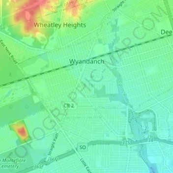
Name: Wyandanch topographic map, elevation, terrain.
Average elevation: 21 m
Minimum elevation: 10 m
Maximum elevation: 58 m
Make a donation
Gear up for your next adventure:
As an Amazon Associate, this site earns from qualifying purchases at no extra cost to you.