
Make a donation
Gear up for your next adventure:
As an Amazon Associate, this site earns from qualifying purchases at no extra cost to you.
Vale de Souto topographic map
Click on the map to display elevation.
Make a donation
Gear up for your next adventure:
As an Amazon Associate, this site earns from qualifying purchases at no extra cost to you.
About this map
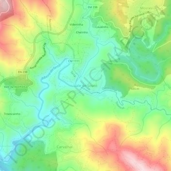
Name: Vale de Souto topographic map, elevation, terrain.
Location: Vale de Souto, Mosteiro, Oleiros, Castelo Branco, Portugal (39.85727 -8.00243 39.89727 -7.96243)
Average elevation: 501 m
Minimum elevation: 354 m
Maximum elevation: 736 m
Make a donation
Gear up for your next adventure:
As an Amazon Associate, this site earns from qualifying purchases at no extra cost to you.
Other topographic maps
Click on a map to view its topography, its elevation and its terrain.
Aldeia do Bispo, Águas e Aldeia de João Pires
Portugal > Castelo Branco > Penamacor
Average elevation: 429 m
Make a donation
Gear up for your next adventure:
As an Amazon Associate, this site earns from qualifying purchases at no extra cost to you.
Make a donation
Gear up for your next adventure:
As an Amazon Associate, this site earns from qualifying purchases at no extra cost to you.
Vila de Rei
At the small town of Vila de Rei, it is worth admiring the 18th century Parish Church and the Miserichord Chapel. A natural curiosity of Vila de Rei is the Penedo Furado (pierced boulder), which has been adapted to shelter two belvederes, set on a rocky platform surrounded by woods and small water-falls. The…
Average elevation: 281 m
Make a donation
Gear up for your next adventure:
As an Amazon Associate, this site earns from qualifying purchases at no extra cost to you.
Make a donation
Gear up for your next adventure:
As an Amazon Associate, this site earns from qualifying purchases at no extra cost to you.
Covilhã
The cold increases according to altitude, varying from higher temperatures in the lower parts of the municipality, to colder temperatures with frequent and sometimes abundant snowfalls during the cold months in the higher areas, such as Penhas da Saúde, above 1,500 meters of altitude, 9 km away from the…
Average elevation: 710 m
Make a donation
Gear up for your next adventure:
As an Amazon Associate, this site earns from qualifying purchases at no extra cost to you.
Vila de Rei
At the small town of Vila de Rei, it is worth admiring the 18th century Parish Church and the Miserichord Chapel. A natural curiosity of Vila de Rei is the Penedo Furado (pierced boulder), which has been adapted to shelter two belvederes, set on a rocky platform surrounded by woods and small water-falls. The…
Average elevation: 281 m
Make a donation
Gear up for your next adventure:
As an Amazon Associate, this site earns from qualifying purchases at no extra cost to you.
Make a donation
Gear up for your next adventure:
As an Amazon Associate, this site earns from qualifying purchases at no extra cost to you.
Make a donation
Gear up for your next adventure:
As an Amazon Associate, this site earns from qualifying purchases at no extra cost to you.
Idanha-a-Nova
Idanha-a-Nova has a Mediterranean climate (Köppen: Csa) with cool to mild, rainy winters and hot, dry summers. The town is located at roughly 380 m (1,250 ft) altitude. Places at lower elevations (e.g. Ladoeiro, shown below) can get even hotter in the summer, with average daily temperatures rounding 33–34…
Average elevation: 321 m
Juncal do Campo
Portugal > Castelo Branco > Freixial do Campo e Juncal do Campo
Average elevation: 302 m
Make a donation
Gear up for your next adventure:
As an Amazon Associate, this site earns from qualifying purchases at no extra cost to you.
Make a donation
Gear up for your next adventure:
As an Amazon Associate, this site earns from qualifying purchases at no extra cost to you.
Poço do Forno Velho
Portugal > Castelo Branco > Covilhã > Cortes do Meio > Bouça
Average elevation: 895 m
Make a donation
Gear up for your next adventure:
As an Amazon Associate, this site earns from qualifying purchases at no extra cost to you.