Geolocate

Uriyacode topographic map

Click on the map to display elevation.

About this map

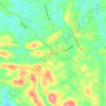
Name: Uriyacode topographic map, elevation, terrain.

Location: Uriyacode, Kattakkada, Thiruvananthapuram, Kerala, 695543, India (8.53099 77.04658 8.57099 77.08658)

Average elevation: 90 m

Minimum elevation: 46 m

Maximum elevation: 157 m

Other topographic maps

Click on a map to view its topography, its elevation and its terrain.

Poovachal

India > Kerala > Kattakkada > Uriyacode

Average elevation: 84 m

Vellanad

India > Kerala > Kattakkada > Uriyacode

Average elevation: 77 m

Kattachal chira

India > Kerala > Kattakkada > Kattakada

Average elevation: 75 m

Vellanad

India > Kerala > Kattakkada > Uriyacode

Average elevation: 77 m

Amboori

India > Kerala > Kattakkada

Average elevation: 173 m

Gear up for your next adventure:

🧢Beanie Hat - Keep your head warm in cold weather
🔦LED Headtorch - Bright and durable light for night activities
🥫Freeze-Dried Meals - Lightweight, high-calorie nutrition for multi-day treks
🧴Sunscreen SPF - Broad-spectrum sunscreen for outdoor activities
🥾Lightweight Hiking Boots - Boots for comfort and mobility on long hikes

As an Amazon Associate, this site earns from qualifying purchases at no extra cost to you.