
Guanacaste topographic map
Click on the map to display elevation.
Guanacaste
Guanacaste's climate and culture are unique among Costa Rican provinces. The province experiences little rain and consistent heat from November to April, resulting in ubiquitous tropical dry forests as a natural adaption to the dry season conditions. Tourists seek out this dry heat during the North American winter to enjoy the Guanacastecan beaches. Irrigation of the agricultural land is necessary during the long dry period. From May to October, the climate is similar to that of San José, consisting of showers daily and moderate temperatures. Guanacaste is, however, considerably warmer than other provinces in the country located in higher elevations.
About this map
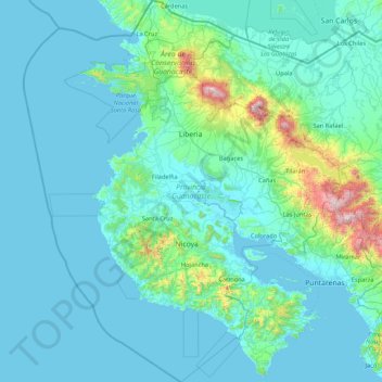
Name: Guanacaste topographic map, elevation, terrain.
Location: Guanacaste, Costa Rica (9.53777 -86.18395 11.21957 -84.76616)
Average elevation: 137 m
Minimum elevation: -1 m
Maximum elevation: 1,882 m
Other topographic maps
Click on a map to view its topography, its elevation and its terrain.
Monteverde Cloud Forest Reserve
Costa Rica > Cantón Monteverde > Monteverde > Santa Elena
Average elevation: 1,539 m
Cartago
Costa Rica > Cantón Cartago > Oriental
It has an elevation of 1,435 m (4,708 ft) above sea level, at the base of the Irazú Volcano.
Average elevation: 1,706 m
San Rafael Norte
Costa Rica > Cantón Pérez Zeledón > San Isidro de El General
Average elevation: 911 m
Arenal Volcano
Costa Rica > Alajuela Province > Cantón de San Carlos > La Fortuna
Arenal has several eruptive vents. Chato is a dormant stratovolcanic cone. It is believed that Chato first erupted 38,000 years ago during the Pleistocene period and last erupted about 3,500 years ago. Chatito is a lava dome with an elevation of 1,100 metres (3,609 ft). Espina is another lava dome.
Average elevation: 1,014 m
Grande River
Costa Rica > Alajuela Province > San Ramón > San Isidro > San Roque
Average elevation: 1,045 m
La Paz
Costa Rica > Alajuela Province > Cantón de San Ramón > Piedades Norte
Average elevation: 1,166 m