
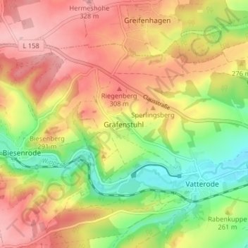
Gräfenstuhl topographic map
Interactive map
Click on the map to display elevation.
About this map
Name: Gräfenstuhl topographic map, elevation, terrain.
Average elevation: 261 m
Minimum elevation: 175 m
Maximum elevation: 337 m
Other topographic maps
Click on a map to view its topography, its elevation and its terrain.
Siebigerode
Deutschland > Sachsen-Anhalt > Mansfeld-Südharz > Mansfeld
Siebigerode, Mansfeld, Mansfeld-Südharz, Sachsen-Anhalt, 06343, Deutschland
Average elevation: 284 m
Großörner
Deutschland > Sachsen-Anhalt > Mansfeld-Südharz > Mansfeld
Großörner, Mansfeld, Mansfeld-Südharz, Sachsen-Anhalt, Deutschland
Average elevation: 212 m
Braunschwende
Deutschland > Sachsen-Anhalt > Mansfeld-Südharz > Mansfeld
Braunschwende, Mansfeld, Mansfeld-Südharz, Sachsen-Anhalt, Deutschland
Average elevation: 345 m
Molmerswende
Deutschland > Sachsen-Anhalt > Mansfeld-Südharz > Mansfeld
Molmerswende, Mansfeld, Mansfeld-Südharz, Sachsen-Anhalt, Deutschland
Average elevation: 309 m