Geolocate

San Isidro topographic map

Click on the map to display elevation.

About this map

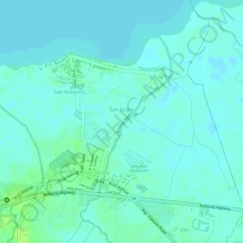
Name: San Isidro topographic map, elevation, terrain.

Location: San Isidro, Bay, Laguna, Calabarzon, 4033, Philippines (14.18332 121.28272 14.19176 121.28962)

Average elevation: 4 m

Minimum elevation: -1 m

Maximum elevation: 13 m

Gear up for your next adventure:

🥾Hiking Gaiters - Protect legs and shoes from mud, snow, and debris
💧Collapsible Water Bottle - Space-saving water bottle for outdoor activities
🔋Lithium AA Batteries - Long-lasting power that performs in extreme cold
🧭GPS Handheld Device - Reliable GPS navigation for outdoor adventures
🧴Insect Repellent - Protect yourself from bugs during outdoor adventures

As an Amazon Associate, this site earns from qualifying purchases at no extra cost to you.