Geolocate

Plauen topographic map

Click on the map to display elevation.

About this map
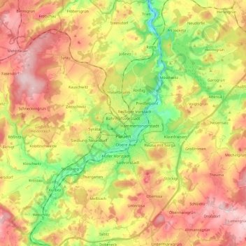
Name: Plauen topographic map, elevation, terrain.

Location: Plauen, Vogtlandkreis, Saxony, Germany (50.43067 12.05966 50.57489 12.22945)

Average elevation: 429 m

Minimum elevation: 300 m

Maximum elevation: 553 m

Other topographic maps

Click on a map to view its topography, its elevation and its terrain.

Gippe

Germany > Saxony > Vogtlandkreis > Elsterberg

Average elevation: 358 m

Mühlleithen

Germany > Saxony > Vogtlandkreis > Klingenthal

Average elevation: 825 m

Röthenbach

Germany > Saxony > Vogtlandkreis > Bad Brambach > Hohendorf

Average elevation: 641 m

Gear up for your next adventure:

🧣Evaporative Cooling Towel - Beat the heat during intense summer climbs
🪑Ultralight Camping Stool - Compact seating for rest stops during long hikes
🔭Compact Monocular - One-handed bird watching and trail spotting
🧴Sunscreen SPF - Broad-spectrum sunscreen for outdoor activities
🧴Outdoor Sunscreen - High SPF protection for high-altitude UV exposure

As an Amazon Associate, this site earns from qualifying purchases at no extra cost to you.