Geolocate

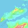
Glenbeigh topographic map

Click on the map to display elevation.

About this map

Name: Glenbeigh topographic map, elevation, terrain.

Location: Glenbeigh, Kenmare Municipal District, County Kerry, Munster, Ireland (52.03605 -9.95942 52.07605 -9.91942)

Average elevation: 97 m

Minimum elevation: -3 m

Maximum elevation: 489 m

Other topographic maps

Click on a map to view its topography, its elevation and its terrain.

Gear up for your next adventure:

📷Outdoor Action Camera - Capture high-elevation views and rugged adventures
🧥Ultralight Puffy Jacket - Maximum warmth that packs down to the size of an orange
🥾Waterproof Trail Shoes - Shoes designed to handle wet terrain
🧳Compression Sacks - Maximize space in your backpack by shrinking gear
🧴Outdoor Sunscreen - High SPF protection for high-altitude UV exposure

As an Amazon Associate, this site earns from qualifying purchases at no extra cost to you.