Geolocate

Karlskoga topographic map

Click on the map to display elevation.

Karlskoga

Karlskoga straddles the northern shore of Lake Möckeln. Among the city's main topographical features are the two rivers, Timsälven and Svartälven. Other features include an esker, Rävåsen, designated as a nature reserve, and contiguous with the city center.

Wikipedia (CC-BY-SA 3.0)

About this map

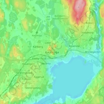
Name: Karlskoga topographic map, elevation, terrain.

Location: Karlskoga, Karlskoga kommun, Örebro County, 691 34, Sweden (59.28917 14.47769 59.36917 14.55769)

Average elevation: 124 m

Minimum elevation: 86 m

Maximum elevation: 235 m

Other topographic maps

Click on a map to view its topography, its elevation and its terrain.

Hallsbergs kommun

Sweden > Örebro County

Average elevation: 92 m

Malingsbo-Kloten

Sweden > Örebro County

Average elevation: 274 m

Laxå kommun

Sweden > Örebro County

Average elevation: 116 m

Örebro kommun

Sweden > Örebro County

Average elevation: 64 m

Örebro kommun

Sweden > Örebro County

Average elevation: 64 m

Gear up for your next adventure:

🧢Outdoor Cap - Protective cap for sun and rain during hikes
🧭Orienteering Kit - Tools for map reading and navigation in the wild
🧶550 Survival Paracord - Versatile utility cord for emergency repairs and rigging
🔥Camping Stove - Portable stoves to cook outdoors with ease
🛏️Camping Sleeping Mat - Comfortable mats for sleeping outdoors

As an Amazon Associate, this site earns from qualifying purchases at no extra cost to you.