Geolocate

Pāremoremo topographic map

Click on the map to display elevation.

About this map
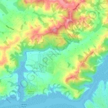
Name: Pāremoremo topographic map, elevation, terrain.

Location: Pāremoremo, Upper Harbour, Auckland, 0793, New Zealand (-36.77325 174.62835 -36.73325 174.66835)

Average elevation: 47 m

Minimum elevation: -2 m

Maximum elevation: 127 m

Other topographic maps

Click on a map to view its topography, its elevation and its terrain.

North Shore

New Zealand > Auckland > Upper Harbour

Average elevation: 29 m

Gear up for your next adventure:

🌬️Windproof Camp Stove - Efficient cooking even on exposed mountain peaks
🧭GPS Handheld Device - Reliable GPS navigation for outdoor adventures
🔦LED Headlamp - Hands-free lighting for early morning starts or late finishes
🎒Backpack Rain Cover - External shield to keep your entire pack dry
🦶Anti-Blister Balm - Prevents friction and hotspots during long ascents

As an Amazon Associate, this site earns from qualifying purchases at no extra cost to you.