
Make a donation
Gear up for your next adventure:
As an Amazon Associate, this site earns from qualifying purchases at no extra cost to you.
Paris Township topographic map
Click on the map to display elevation.
Make a donation
Gear up for your next adventure:
As an Amazon Associate, this site earns from qualifying purchases at no extra cost to you.
About this map
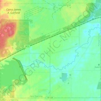
Name: Paris Township topographic map, elevation, terrain.
Location: Paris Township, Portage County, Ohio, 44285, United States (41.13388 -81.09951 41.20270 -81.00238)
Average elevation: 299 m
Minimum elevation: 274 m
Maximum elevation: 350 m
Make a donation
Gear up for your next adventure:
As an Amazon Associate, this site earns from qualifying purchases at no extra cost to you.
Other topographic maps
Click on a map to view its topography, its elevation and its terrain.
Tom S Cooperrider-Kent Bog State Nature Preserve
United States > Ohio > Portage County
Average elevation: 335 m
Make a donation
Gear up for your next adventure:
As an Amazon Associate, this site earns from qualifying purchases at no extra cost to you.
Nelson Ledges Quarry Park
United States > Ohio > Portage County > Garrettsville
Average elevation: 306 m
Make a donation
Gear up for your next adventure:
As an Amazon Associate, this site earns from qualifying purchases at no extra cost to you.