
Make a donation
Gear up for your next adventure:
As an Amazon Associate, this site earns from qualifying purchases at no extra cost to you.
Sohl topographic map
Click on the map to display elevation.
Make a donation
Gear up for your next adventure:
As an Amazon Associate, this site earns from qualifying purchases at no extra cost to you.
Sohl
Im 18. Jahrhundert gehörte der Ort zum bergischen Amt Bornefeld-Hückeswagen. 1815/16 lebten neun Einwohner im Ort. 1832 gehörte Sohl der Großen Honschaft an, die ein Teil der Hückeswagener Außenbürgerschaft innerhalb der Bürgermeisterei Hückeswagen war. Der laut der Statistik und Topographie des Regierungsbezirks Düsseldorf als Weiler kategorisierte Ort besaß zu dieser Zeit ein Wohnhaus und ein landwirtschaftliches Gebäude. Zu dieser Zeit lebten 14 Einwohner im Ort, allesamt evangelischen Glaubens.
Make a donation
Gear up for your next adventure:
As an Amazon Associate, this site earns from qualifying purchases at no extra cost to you.
About this map
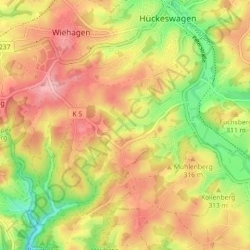
Name: Sohl topographic map, elevation, terrain.
Average elevation: 300 m
Minimum elevation: 224 m
Maximum elevation: 361 m
Make a donation
Gear up for your next adventure:
As an Amazon Associate, this site earns from qualifying purchases at no extra cost to you.
Other topographic maps
Click on a map to view its topography, its elevation and its terrain.
42499
Deutschland > Nordrhein-Westfalen > Oberbergischer Kreis > Hückeswagen > Aue
Average elevation: 292 m