
Make a donation
Gear up for your next adventure:
As an Amazon Associate, this site earns from qualifying purchases at no extra cost to you.
Municipio Mocomoco topographic map
Click on the map to display elevation.
Make a donation
Gear up for your next adventure:
As an Amazon Associate, this site earns from qualifying purchases at no extra cost to you.
About this map
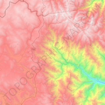
Name: Municipio Mocomoco topographic map, elevation, terrain.
Average elevation: 3,820 m
Minimum elevation: 1,632 m
Maximum elevation: 5,057 m
Make a donation
Gear up for your next adventure:
As an Amazon Associate, this site earns from qualifying purchases at no extra cost to you.
Other topographic maps
Click on a map to view its topography, its elevation and its terrain.
Chaguaya Centro
Bolivia > La Paz > Provincia de Eliodoro Camacho > Municipio Puerto Carabuco
Average elevation: 3,845 m
Puerto Acosta
Bolivia > La Paz > Provincia de Eliodoro Camacho > Municipio Puerto Acosta
Average elevation: 3,945 m
Puerto Carabuco
Bolivia > La Paz > Provincia de Eliodoro Camacho > Municipio Puerto Carabuco
Average elevation: 3,850 m
Make a donation
Gear up for your next adventure:
As an Amazon Associate, this site earns from qualifying purchases at no extra cost to you.
Santiago de Okola
Bolivia > La Paz > Provincia de Eliodoro Camacho > Municipio Puerto Carabuco
Average elevation: 3,893 m
Río Huaycho
Bolivia > La Paz > Provincia de Eliodoro Camacho > Municipio Puerto Acosta
Average elevation: 3,958 m