Geolocate

Candelaria topographic map

Click on the map to display elevation.

About this map

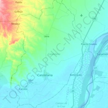
Name: Candelaria topographic map, elevation, terrain.

Location: Candelaria, Atlántico, RAP Caribe, Colombia (10.41165 -74.93092 10.56902 -74.81882)

Average elevation: 30 m

Minimum elevation: 2 m

Maximum elevation: 170 m

Gear up for your next adventure:

Family Camping Tent - Spacious tent suitable for family camping trips
🧣Evaporative Cooling Towel - Beat the heat during intense summer climbs
🦟Insect Repellent - Keep mosquitoes and black flies away in wooded areas
🧤Insulated Winter Gloves - Heavy-duty protection for sub-zero Canadian adventures
🥾Trekking Poles - Adjustable trekking poles to reduce knee stress and improve stability

As an Amazon Associate, this site earns from qualifying purchases at no extra cost to you.