Geolocate

Bisbrooke topographic map

Click on the map to display elevation.

About this map

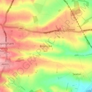
Name: Bisbrooke topographic map, elevation, terrain.

Location: Bisbrooke, Rutland, England, LE15 9EJ, United Kingdom (52.56761 -0.71423 52.60761 -0.67423)

Average elevation: 104 m

Minimum elevation: 41 m

Maximum elevation: 152 m

Other topographic maps

Click on a map to view its topography, its elevation and its terrain.

North Luffenham

United Kingdom > England > Rutland

Average elevation: 83 m

Market Overton

United Kingdom > England > Rutland

Average elevation: 129 m

Ketton

United Kingdom > England > Rutland

Average elevation: 68 m

Gear up for your next adventure:

👟Leg Gaiters - Keep debris, mud, and snow out of your boots
Camping Tent - Weather-resistant tents suitable for 2 to 6 people
🥾Trail Running Boots - Durable shoes designed for trail running
🥾Durable Hiking Shoes - Long-lasting shoes for frequent hiking
🛶Kayak Accessories - Essential gear for safe and fun kayaking adventures

As an Amazon Associate, this site earns from qualifying purchases at no extra cost to you.