Geolocate

Dasu topographic map

Click on the map to display elevation.

About this map

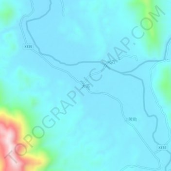
Name: Dasu topographic map, elevation, terrain.

Location: Dasu, Guilin, Guangxi, China (24.91505 110.01345 24.95505 110.05345)

Average elevation: 198 m

Minimum elevation: 144 m

Maximum elevation: 611 m

Other topographic maps

Click on a map to view its topography, its elevation and its terrain.

Pingle County

China > Guangxi > Guilin

Average elevation: 390 m

Xiangshan District

China > Guangxi > Guilin

Average elevation: 179 m

Yangshuo County

China > Guangxi > Guilin

Average elevation: 319 m

Yangshuo County

China > Guangxi > Guilin

Average elevation: 319 m

Gear up for your next adventure:

Lightweight Camping Tent - Portable shelter optimized for Canadian backcountry camping
🥾Light Trekking Boots - Supportive boots for multi-day treks
🥾Light Hiking Boots - Lightweight and comfortable boots for day hikes
🥾Hiking Gaiters - Protect legs and shoes from mud, snow, and debris
🦌Outdoor Trail Camera - Monitor wildlife activity near your favorite spots

As an Amazon Associate, this site earns from qualifying purchases at no extra cost to you.