
Pimentel topographic map
Interactive map
Click on the map to display elevation.
About this map
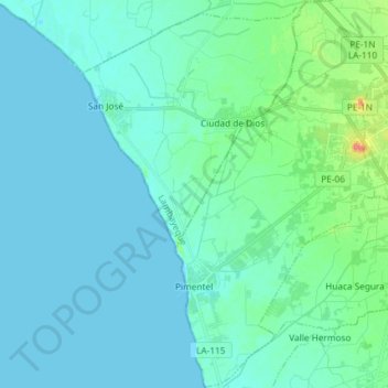
Name: Pimentel topographic map, elevation, terrain.
Location: Pimentel, Chiclayo, Lambayeque, Perú (-6.87362 -79.94289 -6.72805 -79.85479)
Average elevation: 9 m
Minimum elevation: 0 m
Maximum elevation: 61 m
Other topographic maps
Click on a map to view its topography, its elevation and its terrain.
Puerto Etén
Perú > Lambayeque > Etén Puerto
Puerto Etén, Etén Puerto, Chiclayo, Lambayeque, Perú
Average elevation: 11 m
Kañaris
Perú > Lambayeque > Cañaris
Kañaris, Cañaris, Ferreñafe, Lambayeque, Perú
Average elevation: 2,589 m
Chiclayo
Perú > Lambayeque > Chiclayo
Chiclayo, Provincia de Chiclayo, Lambayeque, 5174, Perú
Average elevation: 39 m
Incahuasi
Perú > Lambayeque > Incahuasi
Incahuasi, Provincia de Ferreñafe, Lambayeque, Perú
Average elevation: 2,663 m
La Victoria
Perú > Lambayeque > La Victoria
La Victoria, Provincia de Chiclayo, Lambayeque, 074, Perú
Average elevation: 24 m
Provincia de Chiclayo
Perú > Lambayeque > Pucalá
Provincia de Chiclayo, Pucalá, Chiclayo, Lambayeque, Perú
Average elevation: 348 m