Geolocate

Mintraching topographic map

Click on the map to display elevation.

About this map

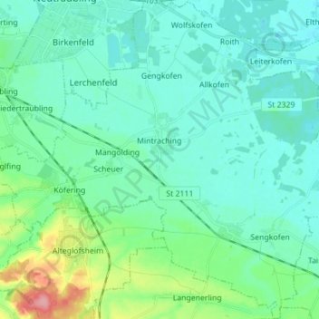
Name: Mintraching topographic map, elevation, terrain.

Location: Mintraching, Landkreis Regensburg, Bavaria, 93098, Germany (48.90047 12.19341 48.99183 12.32944)

Average elevation: 341 m

Minimum elevation: 323 m

Maximum elevation: 419 m

Other topographic maps

Click on a map to view its topography, its elevation and its terrain.

Langenerling

Germany > Bavaria > Landkreis Regensburg

Average elevation: 355 m

Eggmühl

Germany > Bavaria > Landkreis Regensburg

Average elevation: 382 m

Wahlsdorf

Germany > Bavaria > Landkreis Regensburg

Average elevation: 435 m

Gear up for your next adventure:

🛌Insulated Sleeping Pad - Critical thermal barrier between you and the cold ground
Lightweight Backpacking Tent - Compact tent for efficient hiking trips
💡Portable Camping Lamp - Rechargeable lamp for campsite lighting
🛏️Camping Sleeping Mat - Comfortable mats for sleeping outdoors
🥾Hiking Gaiters - Protect legs and shoes from mud, snow, and debris

As an Amazon Associate, this site earns from qualifying purchases at no extra cost to you.