
Thank you for supporting this site ❤️
Make a donation
Make a donation
Gear up for your next adventure:
As an Amazon Associate, this site earns from qualifying purchases at no extra cost to you.
Castril topographic map
Click on the map to display elevation.
Thank you for supporting this site ❤️
Make a donation
Make a donation
Gear up for your next adventure:
As an Amazon Associate, this site earns from qualifying purchases at no extra cost to you.
About this map
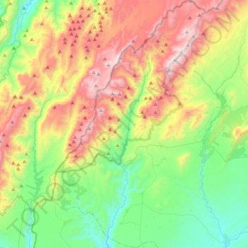
Name: Castril topographic map, elevation, terrain.
Location: Castril, Comarca de Huéscar, Granada, Andalusia, 18816, Spain (37.70921 -2.88029 37.97445 -2.68377)
Average elevation: 1,248 m
Minimum elevation: 719 m
Maximum elevation: 2,129 m
Thank you for supporting this site ❤️
Make a donation
Make a donation
Gear up for your next adventure:
As an Amazon Associate, this site earns from qualifying purchases at no extra cost to you.
Other topographic maps
Click on a map to view its topography, its elevation and its terrain.
Piedra del Águila
Spain > Andalusia > Comarca de Huéscar > Puebla de Don Fadrique
Average elevation: 1,295 m