Geolocate

Geeveston topographic map

Click on the map to display elevation.

About this map

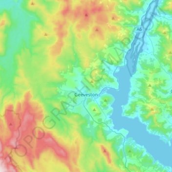
Name: Geeveston topographic map, elevation, terrain.

Location: Geeveston, Huon Valley, Tasmania, 7116, Australia (-43.25482 146.77526 -43.05326 146.96361)

Average elevation: 237 m

Minimum elevation: -3 m

Maximum elevation: 865 m

Other topographic maps

Click on a map to view its topography, its elevation and its terrain.

Frog Hill

Australia > Tasmania

Average elevation: 875 m

Mount Kate

Australia > Tasmania

Average elevation: 995 m

Tasman Peninsula

Australia > Tasmania > Tasman > Fortescue

Average elevation: 167 m

Mount Jukes

Australia > Tasmania

Average elevation: 773 m

Ulverstone

Australia > Tasmania > Ulverstone

Average elevation: 37 m

Bullock Hill

Australia > Tasmania > Grove

Average elevation: 147 m

Highland Waters

Australia > Tasmania > London Lakes

Average elevation: 759 m

Stillwater Hill

Australia > Tasmania

Average elevation: 353 m

Legges Tor

Australia > Tasmania

Average elevation: 1,457 m

Rowlands Hill

Australia > Tasmania

Average elevation: 388 m

Recherche Bay

Australia > Tasmania

Average elevation: 10 m

Bastyan Dam

Australia > Tasmania > Tullah

Average elevation: 233 m

Gear up for your next adventure:

🥾Approach Boots - Comfortable boots for hiking and climbing approaches
🧴First Aid Kit - Essential first aid supplies for outdoor emergencies
🥾Mountaineering Boots - Supportive boots for climbing and high-altitude hiking
🥾Mountain Hiking Shoes - Shoes with superior grip for mountainous terrain
📷Outdoor Action Camera - Capture high-elevation views and rugged adventures

As an Amazon Associate, this site earns from qualifying purchases at no extra cost to you.