
Make a donation
Gear up for your next adventure:
As an Amazon Associate, this site earns from qualifying purchases at no extra cost to you.
Nowthen topographic map
Click on the map to display elevation.
Make a donation
Gear up for your next adventure:
As an Amazon Associate, this site earns from qualifying purchases at no extra cost to you.
About this map
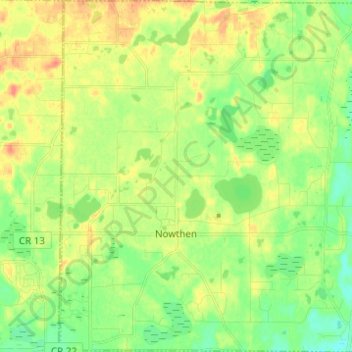
Name: Nowthen topographic map, elevation, terrain.
Location: Nowthen, Anoka County, Minnesota, United States (45.29889 -93.51099 45.38552 -93.38839)
Average elevation: 284 m
Minimum elevation: 265 m
Maximum elevation: 305 m
Make a donation
Gear up for your next adventure:
As an Amazon Associate, this site earns from qualifying purchases at no extra cost to you.
Other topographic maps
Click on a map to view its topography, its elevation and its terrain.
Make a donation
Gear up for your next adventure:
As an Amazon Associate, this site earns from qualifying purchases at no extra cost to you.
Rum River North County Park
United States > Minnesota > Anoka County > Saint Francis
Average elevation: 279 m