
Make a donation
Gear up for your next adventure:
As an Amazon Associate, this site earns from qualifying purchases at no extra cost to you.
Wesendorf topographic map
Click on the map to display elevation.
Make a donation
Gear up for your next adventure:
As an Amazon Associate, this site earns from qualifying purchases at no extra cost to you.
Wesendorf
Im Westen der Ortsgemarkung erstreckt sich die mit Sanden überzogenen Grundmoränenhochfläche der Ringelahs Heide und der Brutlohsheide. Sie geht von West nach Ost in die Niederungszone des Großen Moores und speziell des kleineren Heestenmoores über. Hier hatte sich die Schmelzwasserabflussrinne des Isetales gebildet. Der größere westliche Teil der Gemarkung besitzt ein schwaches Kleinrelief. Es fällt nach Osten von 67 auf 58 Meter NN ab. Der kleinere Ost-Teil im Heestenmoor hat eine Höhe von 56 bis 57 Meter NN. Der Ort liegt am Ostrand der Brutlohsheide mit seinem Kern in einer flachen süd-exponierten Hanglage von 63 bis 65 Meter NN. Die neuen Ortsteile ziehen sich in geringer Neigung nach Osten bis auf 62 Meter und nach Süden bis 60 Meter NN herab. Die Ortschaft mit seinen Gemarkungsgrenzen liegt am südöstlichen Rand des Naturpark Südheide und hat keine auffällige Topografie.
Make a donation
Gear up for your next adventure:
As an Amazon Associate, this site earns from qualifying purchases at no extra cost to you.
About this map
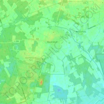
Name: Wesendorf topographic map, elevation, terrain.
Average elevation: 62 m
Minimum elevation: 52 m
Maximum elevation: 81 m
Make a donation
Gear up for your next adventure:
As an Amazon Associate, this site earns from qualifying purchases at no extra cost to you.
Other topographic maps
Click on a map to view its topography, its elevation and its terrain.