
Make a donation
Gear up for your next adventure:
As an Amazon Associate, this site earns from qualifying purchases at no extra cost to you.
Hösbach topographic map
Click on the map to display elevation.
Make a donation
Gear up for your next adventure:
As an Amazon Associate, this site earns from qualifying purchases at no extra cost to you.
Hösbach
Der topographisch höchste Punkt der Gemeinde ist der Gipfel des Rottenberges nordöstlich von Rottenberg mit 408 m ü. NHN (Lage)50.044679.24398, der niedrigste liegt an der Aschaff auf 134 m ü. NHN (Lage)49.998269.1955.
Make a donation
Gear up for your next adventure:
As an Amazon Associate, this site earns from qualifying purchases at no extra cost to you.
About this map
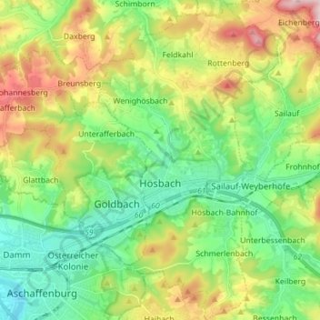
Name: Hösbach topographic map, elevation, terrain.
Location: Hösbach, Landkreis Aschaffenburg, Bayern, 63768, Deutschland (49.96646 9.17373 50.05607 9.25265)
Average elevation: 223 m
Minimum elevation: 106 m
Maximum elevation: 439 m
Make a donation
Gear up for your next adventure:
As an Amazon Associate, this site earns from qualifying purchases at no extra cost to you.