
Make a donation
Gear up for your next adventure:
As an Amazon Associate, this site earns from qualifying purchases at no extra cost to you.
Petrovaradin topographic map
Click on the map to display elevation.
Make a donation
Gear up for your next adventure:
As an Amazon Associate, this site earns from qualifying purchases at no extra cost to you.
Petrovaradin
Petrovaradin is located in the Syrmia region, on the Danube river and Fruška Gora, a horst mountain with elevation of 78–220 m (municipality up to 451 m). The northern part of Fruška Gora consists of massive landslide zones, but they are not active, except in Ribnjak neighborhood (between Sremska Kamenica and Petrovaradin fortress).
Make a donation
Gear up for your next adventure:
As an Amazon Associate, this site earns from qualifying purchases at no extra cost to you.
About this map
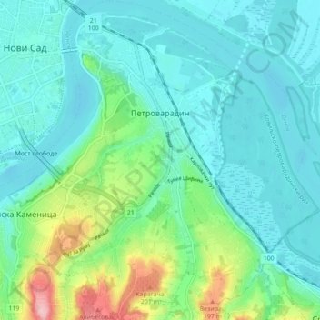
Name: Petrovaradin topographic map, elevation, terrain.
Average elevation: 105 m
Minimum elevation: 69 m
Maximum elevation: 238 m
Make a donation
Gear up for your next adventure:
As an Amazon Associate, this site earns from qualifying purchases at no extra cost to you.
Other topographic maps
Click on a map to view its topography, its elevation and its terrain.
Banstol
Serbia > South Backa Administrative District > Sremski Karlovci Municipality
Average elevation: 222 m