
Make a donation
Gear up for your next adventure:
As an Amazon Associate, this site earns from qualifying purchases at no extra cost to you.
Salar de Uyuni topographic map
Click on the map to display elevation.
Make a donation
Gear up for your next adventure:
As an Amazon Associate, this site earns from qualifying purchases at no extra cost to you.
Salar de Uyuni
Salar de Uyuni is the largest salt flat in the world, with an area of approximately 10,582 square kilometres (4,086 mi2). It is situated in southwestern Bolivia, within the Daniel Campos Province of the Potosí Department, near the crest of the Andes Mountains, at an elevation of 3,656 m (11,995 ft) above sea level.
Make a donation
Gear up for your next adventure:
As an Amazon Associate, this site earns from qualifying purchases at no extra cost to you.
About this map
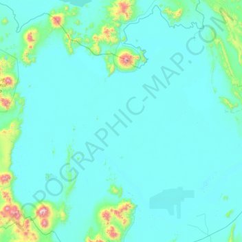
Name: Salar de Uyuni topographic map, elevation, terrain.
Location: Salar de Uyuni, Potosí, Bolivia (-20.72093 -68.27452 -19.68761 -66.90819)
Average elevation: 3,722 m
Minimum elevation: 3,645 m
Maximum elevation: 5,350 m
Make a donation
Gear up for your next adventure:
As an Amazon Associate, this site earns from qualifying purchases at no extra cost to you.
Other topographic maps
Click on a map to view its topography, its elevation and its terrain.
Toro Toro
Bolivia > Potosí > Provincia Charcas > Municipio Toro Toro
Torotoro lies at an altitude of 2,676 m. It can only be reached by road from Estancia Sucusuma at the Río Caine. The town is at the centre of Torotoro National Park. It is 140 km south of Cochabamba.
Average elevation: 2,792 m
Mirador Arco de piedra
Bolivia > Potosí > Provincia Charcas > Municipio Toro Toro
Average elevation: 3,547 m
Make a donation
Gear up for your next adventure:
As an Amazon Associate, this site earns from qualifying purchases at no extra cost to you.
Make a donation
Gear up for your next adventure:
As an Amazon Associate, this site earns from qualifying purchases at no extra cost to you.
Morning Sun
Bolivia > Potosí > Provincia Sur Lípez > Municipio San Pablo de Lipez
Sol de Mañana is an area with geothermal manifestations in southern Bolivia, including fumaroles, hot springs and mud pools. It lies at about 4,900 metres (16,100 ft) elevation, south of Laguna Colorada and east of El Tatio geothermal field. The field is located within the Eduardo Avaroa Andean Fauna National…
Average elevation: 4,894 m
Make a donation
Gear up for your next adventure:
As an Amazon Associate, this site earns from qualifying purchases at no extra cost to you.
Huayllajara
Bolivia > Potosí > Provincia José Maria Linares > Municipio Puna
Average elevation: 3,417 m
Make a donation
Gear up for your next adventure:
As an Amazon Associate, this site earns from qualifying purchases at no extra cost to you.
San Agustin
Bolivia > Potosí > Provincia Enrique Baldivieso > Municipio San Agustin
Average elevation: 3,900 m
Make a donation
Gear up for your next adventure:
As an Amazon Associate, this site earns from qualifying purchases at no extra cost to you.
Alota
Bolivia > Potosí > Provincia Enrique Baldivieso > Municipio San Agustin
Average elevation: 3,816 m
Millares
Bolivia > Potosí > Provincia Cornelio Saavedra > Municipio Betanzos
Average elevation: 2,456 m
Make a donation
Gear up for your next adventure:
As an Amazon Associate, this site earns from qualifying purchases at no extra cost to you.
Laguna Colorada
Bolivia > Potosí > Provincia Sur Lípez > Municipio San Pablo de Lipez
Average elevation: 4,302 m
Uturuncu
Bolivia > Potosí > Provincia Sur Lípez > Municipio San Pablo de Lipez
At an elevation of 6,008 metres (19,711 ft), Uturuncu is the highest mountain in southwestern Bolivia. It dominates the regional geomorphology, rising about 1,510–1,670 metres (4,950–5,480 ft) above the surrounding terrain and presenting a good view of the surrounding mountains from the summit. The volcano…
Average elevation: 5,594 m
Quetena Chico
Bolivia > Potosí > Provincia Sur Lípez > Municipio San Pablo de Lipez > Quetena Chico
Average elevation: 4,196 m
Make a donation
Gear up for your next adventure:
As an Amazon Associate, this site earns from qualifying purchases at no extra cost to you.
San Vicente
Bolivia > Potosí > Sur Chichas > Municipio Atocha > San Vicente
Average elevation: 4,543 m
San Marcos
Bolivia > Potosí > Provincia Modesto Omiste > Villazón > San Marcos
Average elevation: 3,057 m