
Make a donation
Gear up for your next adventure:
As an Amazon Associate, this site earns from qualifying purchases at no extra cost to you.
Torrejón de Ardoz topographic map
Click on the map to display elevation.
Make a donation
Gear up for your next adventure:
As an Amazon Associate, this site earns from qualifying purchases at no extra cost to you.
Torrejón de Ardoz
It is located to the east of the city of Madrid, near the A-2, the highway connecting Madrid and Barcelona. With the city located at the right-bank (north) of the Henares the relief of the municipality gently decreases in elevation from north to south.
Make a donation
Gear up for your next adventure:
As an Amazon Associate, this site earns from qualifying purchases at no extra cost to you.
About this map
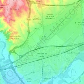
Name: Torrejón de Ardoz topographic map, elevation, terrain.
Average elevation: 604 m
Minimum elevation: 556 m
Maximum elevation: 715 m
Make a donation
Gear up for your next adventure:
As an Amazon Associate, this site earns from qualifying purchases at no extra cost to you.